The next public hearing on the Millers Pond Rezoning will be on Wednesday October 25, 2023 at 7pm at Town Hall.
On September 13, 2023 the Town Board opened a a public hearing is for a local law to approve the zoning requirements for the Millers Pond development at the site of the Minisceongo Golf course.
The local law proposed by the developer sets the rules he wants to follow for future development; and this your opportunity to comment on how you will be impacted by the project and the self created rules the developer is proposing. This is where you have an chance to request modifications and any further studies.
The notice for the public hearing was posted in the Journal News on 8/30/23 and is copied below. A large number of people showed up and several dozen local residents spoke.
The Town web page for all materials related to this hearing is here: https://www.ramapo.org/page/millers-pond-seqra-documents-165.html
The County Planning Department GML letter has not yet been posted. Check for it on this page: http://rocklandgov.com/departments/planning/land-use/general-municipal-law/gml-reviews-by-municipality-2/
More information and ROSA submissions on this project is provided below this notice:
NOTICE OF PUBLIC HEARING TOWN OF RAMAPO TOWN BOARD MILLERS POND PLANNED UNIT DEVELOPMENT PROPOSAL AND LOCAL LAW FOR A PROPOSED AMENDMENT TO THE TOWN OF RAMAPO ZONING CODE AND ZONING MAP FOR PROPERTY LOCATED AT 110-118 POMONA ROAD. RAMAPO, NEW YORK

NOTICE IS HEREBY GIVEN that pursuant to Sections 376-24(B)(3)(d) and 376-172 of the Town of Ramapo Zoning Cede, a public hearing will be held by the Town Board of the Town of Ramapo on September 13th, 2023 at 7:01 PM or as soon thereafter as the matter may be heard, with the pubic hearing record remaining open for written comments until September 22, 2023 at 5:00pm. The public hearing will be held at the Town of Ramapo Town Hal, 237 Route 59, Suffern, New York 10901. The public hearing relates to a planned unit development application and zoning amendment petition submitted by Mount Ivy LLC and Lindifrim (Pomona) LP for an amendment to the Zoning Map and Zoning Code of the Town of Ramapo to rezone certain parcels of land from the RR-80 (Residential District - 80,000 square feet per lot) zoning district to a new Millers Pond Planned Unit Development (MP-PUD) District and relates to the preliminary development plan of the proposed MP-PUD. The proposed local law would establish use, bulk, parking and other requirements applicable to the MP-PUD.

The proposed Millers Pond Planned Unit Development (MP-PUD) is comprised of three parcels which are generally bounded by Samuel G Fisher Mount Ivy Environmental Park to the north, Station Road to the east Pomona Road to the south, and Camp Hill Road to the west and which are more particularly known and designated on the Tax Map of the Town of Ramapo as Tax Map Nos. 33.13-2-6, 33.09-2-31 and 33.09-2-27. The subject property is located at 110-118 Pomona Road and comprises approximately +/-143.6 acres in area. The proposed MP-PUD application and zoning petition, if granted, will approve residential and commercial development on the subject property. All persons interested in the above matter will be given an opportunity to be heard at the public hearing. The Town of Ramapo will make every effort to assure that the hearing is accessible to persons with disabilities. Anyone requiring special assistance and/or reasonable accommodations should contact the Town Clerk.

A copy of the MP-PUD application, zoning amendment petition, proposed local law, preliminary MP-PUD plan, Environmental Assessment Form Supplement and Town of Ramapo Town Board Amended and Supplemental SEQRA Findings and related documents are on file in the Town Clerk's Office at 237 Route 59, Suffern, New York 10901, for public viewing and inspection during normal business hours, and on the Town's website at https://www.ramapo.org/paqe/millers-pond-seqra-documents-165.html.
More Information
Understand What is Being Proposed As Best You Can
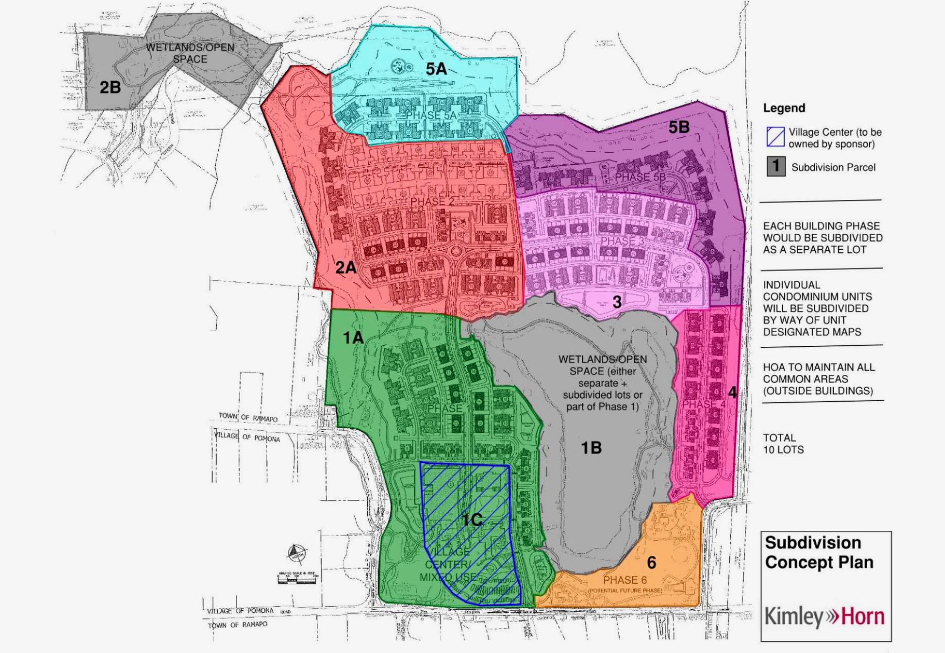
The applicant, Mount Ivy LLC, is seeking to repurpose the vacant golf course along the northern side of Pomona Road for a new residential community with accompanying community center and small retail uses. The Applicant proposes to develop a residential community consisting of 637 residential units (102
apartments + 535 townhomes), 20,000 SF of retail space, a 45,000 sf, 48-room hotel, and 38,000 SF of community/amenity space. Approvals and construction is projected to continue through 2027.
The site as proposed is 143.6 acres made up from the 3 lots that were part of the Minisceongo Golf Course. The main parcel is Lot 33.13-2-6 containing 129.57 acres. There are two additional parcels obtained in 1992 as part of parkland land swap with Rockland County that are being included for acreage that are not being developed: Lot 33.09-2-37 at 7.2 acres and Lot 33.09-2-31 at 7.3 acres.
Wetlands – The site has 17 acres of DEC wetlands which were delineated and confirmed by the DEC. (See Exhibit B to the proposed local law in Appendix K).
Public Water Supply – The proposed development is within very close proximity of the Camp Hill Road Veolia Public Water Wells and ROSA advocated for the elimination of development of basements to reduce groundwater impact. There are comments on this in Appendix D but no study. A check of Appendix A does indicate 257 units proposed without basements.
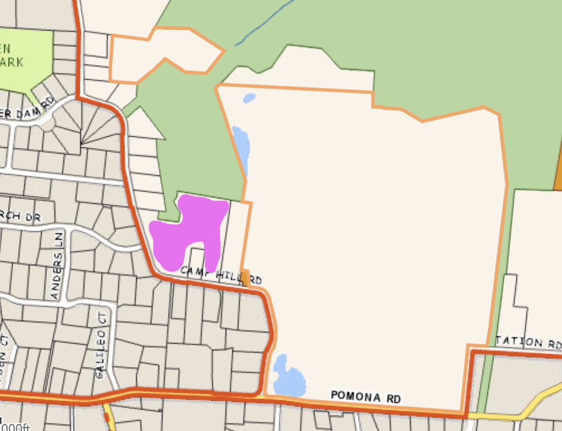
Scenic Road District – 1,000′ on either side of Camp Hill Road is a designated Scenic Road District subject to special review and planning rule under Ramapo Code Chapter 215. There has been limited discussion of the impacts in the Northeast DGEIS and in the PUD application paperwork but we have not yet found any map depicting an overlay of the district on the proposed development. The applicant is reluctant to move the proposed large in volume and height multi family building from its proposed location.
Traffic – This is a known concern of local residents and residents in Ramapo that regularly travel on Camp Hill Road and Pomona Road. The roads generally have lighter traffic but are impacted by rush hour traffic, school traffic and ballfield traffic – mostly at the Route 45 and Pomona Road intersection. There is a traffic study submitted for the project – see Appendix I. It appears to consider some cumulative impact by rezoning projects like Patrick Farm, Matterhorn and Tartikov but does not consider the impacts of other areas for rezoning in the Village of New Hempstead in their 2020 Comprehensive Plan or the impacts of the 2022 rezoning of all of Route 202 from Camp Hill Road to the Mount Ivy Diner to the new Commercial Corridor multi use zoning. Before analyzing traffic studies it is important to first confirm all assumptions being relied on.
Visual Impact and Community Character – This is a concern raised a lot by neighbors and resident using Pomona Road to get from Rt 306 to 45 or those that use Camp Hill Road to get to Rt 202. The DGEIS Appendix M contains the information on MIllers Pond considered for the DGEIS. It included visual renderings but no visual impact study or consideration of alternatives. There were visual rendering of the project from Camp Hill Road in Appendix G here but nothing from Pomona or Station Road and no analysis of alternatives.
Water – Water planning is a race to see what development is approved first because Veolia and the County are not tracking water requirements for projects that have been approved but not built. This has been something that ROSA has been advocating about to the County and the Public Service Commission and which we were surprised to see admitted to in Appendix D reports. This developer has done a more thorough job of analyzing their water usage than we have seen in any other application however once again we remain concerned as to the hidden water demand of development of vacant lands and redevelopment of existing properties as of right based on existing zoning, and the rezoning of much of the unincorporated Town of Ramapo through zoning variances. Projects approved 15 years ago are finally under development now but not being tracked by anyone. The Town of Ramapo should analyze this situation before any approvals for this and other large scale projects.
Sewer – The Town’s DGEIS admits that this project cannot be supported by existing sewers. It is not clear how much of the improvements required relate specifically to this project and how much to other Northeast projects, whether the proposed expansion in the Village of New Hempstead are accounted for, and how the Town Board can insure that this project covers the costs of required improvements and any increases in future maintenance. Sewer analysis is included in the Appendix D reports.
Roads – The Town positioned the Northeast Opportunity Areas as opportunities to create new walkable village centers. All roads within Millers Ponds appear to be designated to be private roads. We believe that the acreage for roads is being used toward density calculations.
Community Services – The analysis of impacts to emergency and school services in the DGEIS has not been revisted for Millers Pond. Here there has been no discussion of the provision of space within the development project for school buildings to ensure that the impact of new schools for this new community is not transferred to residents in other parts of Ramapo. We could not find any calculation of cost impacts to the ERCSD anywhere. The DGEIS section on impacts to the Hillcrest Fire Department provides no information and defers consideration to future discussions which never happened (see 2022 Findings).
ROSA has advocated for the development of a project DEIS as the Town’s DGEIS project denied the public the opportunity to consider this project at the time of the scoping hearing of August 19, 2019 and the consideration under the Town’s GEIS study, while arguably sufficient to broadly consider the concept of rezoning did not evaluate a specific rezoning plan and did not consider the specifics of this plan. ROSA’s review Planner Jonathan Lockman of Nelson Pope Vorhis submitted comments in February 2023 and the developers professionals did respond somewhat to these comments.
This is the first public hearing on this project’s site plan and proposed local law. You have the right to comment on or question anything. Try to be specific with respect to any questions or concerns. The developer appears interested in addressing public concern and not forcing a rushed decision caused by Town Board hastiness but he is also interested in an approval. If you have concerns participate.
We have gathered up related documents as best we could and we advocated for the Town to post documents on the Town website – see https://www.ramapo.org/page/news-7/news/millers-pond-pud-seqra-documents-930.html Warning: Links below are to the ROSA library and not from this page. Please refer to the Town downloads from this page and may not be the most recent.
If you are concerned about specific aspects of what is proposed be as specific as possible, ask for explanations and details, and make specific requests for changes if necessary. Written comments should be submitted to the Town Clerk Sharon M. Osherovitz by September 22, 2023, osherovitzs@ramapo.org
North East Comprehensive Plan
In July of 2022, the Town of Ramapo passed an amendment to the Town’s Comprehensive Plan related to development in Northeast Ramapo. That update recommends the Minisceongo Golf Course be considered for rezoning under what is now Ramapo § 376-24 “Planned Unit Development District and development” allowing mixed use at significantly higher density.
The analysis for that new zoning code and the recommendation were in a Generic Environmental Impact Study that led to Town Board findings. Documents related to that effort are posted on the PlanRamapo website.
On August 23, 2023 the Town Board approved a Notice of SEQRA Determination for the Millers Pond Project Development Plans and Local Law finding that they adequately considered all environmental impacts in the Northeast Plan GEIS:
NOW THEREFORE, BE IT RESOLVED and PLEASE TAKE NOTICE, that the
See page 31 of 8/23/2023 Notice of SEQR Determination
Town Board, after consideration of all Town consultant comments, Town agency comments, involved and interest agency comments, and application materials submitted by the Petitioner, as well as all matters in the record of these proceedings, on a ROLL CALL VOTE, pursuant to §617.10(d)(2) of the SEQRA Regulations adopts and approves the attached SEQRA Millers Pond PUD Amended and Supplemental Findings Statement in accordance with §617.11 and 617.10 of the SEQRA Regulations and finds that the Project was adequately addressed in the NRDP GEIS and that all Project specific information submitted to the Town Board (as noted above) will not result in any significant environmental impacts that have not or will not be mitigated and a supplemental environmental impact statement is not required.
If you disagree with the Town Boards determination or Amended Findings you must be specific in your request for any change.
Millers Pond Details
The following are excerpted from the submissions posted online we believe are of greatest interest to residents. The developer created a Table of Contents of sorts to the SEQR Appendices they produced which lists the contents.
There is a tremendous quantity of documents and pages to review if you really can’t find something you can Contact Us with questions. Documents which seem of more interest to laypeople are marked with a ❗
- Latest developer document with overall project description ❗
- Proposed Project Site Plans as of 8/14/2023 ❗ Be careful to close other documents, the plans seem to cause computers to hang. Not recommended to open on phones.
- Appendix A – Breakdown of Unit Sizes and Prices for 535 Townhouses ❗
- Appendix B – SWPPP Very technical and specific to site plan.
- Appendix C – ACOE and DEC letters
- Appendix D – Water and Sewer
- Appendix E – Bat studies (yes endangered bats which only precludestree removals at some times of years)
- Appendix F – Tree mapping list showing which trees get cut. Can’t find map that shows the numbers.
- Appendix G – Visual Impact Analysis Camp Hill Road, nothing on Pomona or Station Road❗
- Appendix H – Letters from Division for Historic Preservation of the Office of Parks, Recreation and Historic Preservation (OPRHP)
- Appendix I – Traffic Study ❗
- Appendix J – Air Quality Analysis and Impact Revewi / Greenhouse gas Emissions Analysis
- Appendix K – Proposed Local Law with Exhibits ❗❗
- Appendix L – Fire Safety Engineer review of egress roads (not a general site plan review). (June 12, 2023 Fire Access Roads Separation plan is missing)
Ramapo Current Codes FOR REFERENCE
- Current Town of Ramapo Zoning Code
- Current Town of Ramapo Use Table
- Current Ramapo Bulk Table a.k.a. Dimensional Requirements
❗❗ This is the most important document to comment on. The remaining Town Board act for this project is to approve this local law that sets all the regulations that the project plan must fit in. This is the most important document to consider as it is designed to enable this project.
This is an official public hearing and if you don’t believe they have sufficiently analyzed the environmental impacts of the proposed changes this is the time to say so.
We were very surprised that
Further Comments
2023-02-14: ROSA planner Jonathan Lockman of Nelson Pope Vorhis to submit comments to the CDRC.
2023-08-23: ROSA attorney Emily Svenson of Gordon & Svenson submitted comments to Town Board.
2023-08-23: ROSA comments read at public hearing by Deborah Munitz requesting more time.
The following are initial comments/thoughts/concerns that have been raised to us so far:
Lack of Town Planner Comments – The only Town Planner comments that we could find were buried in an MJ Engineering letter of June 6, 2023.
There is no discussion of impact on community character, building spacing, use of gross lot area instead of net lot area, or any analysis of the density and the logic of rezoning the wetland lots not being developed.
Lack of County Planning Comments – The Rockland County Planning Department GML is not scheduled to be submitted prior to the public hearing.
The Public Needs More Time and Answers – The Town has given the public less than a week – until 9/22/23 – to submit comments but has not provided professional planner reviews. The board should move the due date to 9/29/23 and hold another public hearing on 10/4/23 with a presentation to the public of answers before the public hearing is reopened.
Questions remain – This is a very preliminary list of comments that various people have raised that are being researched further.
- Appendix A shows that the 535 townhouses with projected prices totaling $481,676,015 in sales resulting in an average price of over $900,329. This is a tremendous amount of revenue that does not include the monies generated from the mixed use commercial, the mixed use residential and whatever revenue might come from commercial use of the Club House. All impacts on the neighbors and Town taxpayers should be considered in the light of what is being proposed.
- Appendix A does not include bedroom counts to compare to prior estimates.
- Could not find analysis similar to Appendix A for the 102 apartments – sizes, bedroom count, pricing. Will the apartments be for sale or for rent? The developer states in the proposed Part 3 that all apartments will be for rent how does the local law enforce that? What prevents the conversion of the building to a coop or condo at a later time?
- What percentage of the rentals will be reserved for affordable housing? For workforce housing?
- Could not find housing analysis in Northeast GEIS or in the SEQR materials here that can form the basis for Town Board goals of housing mix to meet residents needs. How does this project provide solutions for young single adults? Young couples without children? Affordable housing for seniors? affordable housing for low income workers and volunteer emergency service workers?
- Could not find location of trees in tree survey in Appendix F. What map can these be found on?
- Could not find cut and fill plans or groundwater level analysis. There is a lot to pore through.
- The local law does not modify the use table and bulk tables and there are no exhibits for what the entries in these tables will look like. Even the MU-3 Local Law for the Watchtower addressed this.
- Where is the analysis by section of the development coverage, development density and floor area ratio so that the Town Board can compare this development against other development in Ramapo.
- Net Area vs Gross Area
- Proposed Local Law is a major department from zoning as it appears to override the provision of §376-42 which accounts for reductions in lot areas and thus density based on recognition that certain lands with encumbrances and easements are not buildable.
- Development coverage proposed is based on gross area not net.
- Density is based on gross area not net (when the Town considered the core PUD regulations and set density limits it did not make an allowance for this departure.
- 17 acres of wetlands * 5 = 85 units. Why are wetlands not removed from calculations?
- Why are roads not removed from calculations, which would happen if this were a subdivision developed under existing zoning? (See Realty Subdivision FAQ #5)
- No calculation of the buildable potential of the 3 lots. There is no basis for comparing the current proposal for what can be built under existing zoning. There is nothing in the DGEIS for Northeast Ramapo that evaluation what kind of subdivision could be built under R-80 zoning or intermediate zoning based on existing zoning standards.
- No Floor Area Ratio has been proposed for residential units.
- Building height limitations as written in the local law is restricted to a single building. What would stop a revised plan following the approval of the local law from including multiple mixed use building from replacing the residential townhomes?
- Local law attempts to override all subdivision regulations and there is no analysis by any Town professional as to what this implies.
- How are the portions of residential vs commercial vs mixed use defined and calculated?
- Where is there any limitation on the ratios of residential to commercial? If this is approved as is, can the developer go to the Planning Board with a plan that includes 6 large commercial buildings? How does this local law prevent changes from the proposed plan?
- Parking:
- Why is there only 1 parking spot per hotel staff?
- For commercial space is 1 space per 200 sufficient? What about difference between office space and retail space?
- For apartments in mixed use building how many bedrooms will there be? Is 1 parking space enough? Young couples may have 2 cars. How will this be accommodated? Is there sufficient visitor parking?
- Parking waiver provisions do not match Town Code 376-70 as there is no requirement to provide for reserve or overflow parking if parking is waived.
- What are the provisions for street parking on each road type?
- There are no plans found that show the Scenic Road District overlaid onto the proposed development plan so that the Town Board and Planning Board can visualize the impacts on the Scenic Road District and amend the local law to better protect the impacts on views in the district.
- Why is there a massive stormwater management facility between the tallest commercial building requiring full clearing of the area between the building and Camp Hill Road in the Scenic Road District? This pushes the impacts of the development onto the public at large and removes the opportunity for very tall mature trees to grow and buffer/screen the view of the tall building.
- Alternatives should be considered to improve the view into the development from Camp Hill Road to better screen the new development and its change in community character from the surrounding neighborhood?
- There appears to little to no screening of the loading dock from Camp Hill Road.
- Where are the visual impact studies of all entrances to the development and from Pomona Road, Station Road and the American Legion?
- How can the local law better address restrictions on basement development to ensure no impact on groundwater flows to public water wells a lot away from the site so that it applies to any changes to the plan before it goes to the Planning Board?
- What infrastructure improvements are necessary to enable this project plan and how will the Town Board protect the taxpayer from footing the bill for these improvements?
- What public recreation areas are being provided or will there be a money-in-lieu of land arrangement? This doesn’t appear specified anywhere?
- Is 20,000 sf of mixed use commercial enough to justify this as fulfilling the intent of rezoning for “placemaking”? And “provide for opportunities for additional needed neighborhood services near existing residential neighborhoods”?
- Where is the review of the road layout to ensure sufficient visitor parking is provided for all types of visitors, contractors, baby sitters, home health aids, service providers, mail carriers and delivery trucks?
- Where are the new school buildings for the new residents. With 600+ units there will be thousands of studies many of which are expected to attend private schools. The impact of schools for the new residents should be borne by the new residents and land sufficient for new students should be accounted for within the PUD development.